Thursday, May 29, 2014

Commitment and Political Courage...

Bike lanes, not parking.
Those are the words that came to mind for me yesterday as I rode through San Francisco and that is what is takes to truly change our roads to be more bike friendly.

It takes a commitment to cycling as a viable form of transportation that deserves to be encouraged by making simple changes to our streets. I saw this commitment displayed in San Francisco by the fact that on pretty much any street that did not have a bike lane, the right lane had been designated as a shared lane by painting the "Sharrow" lane designator.

It is amazing what this simple change to a street does for cyclists. It graphically informs both the driver and the cyclist that this is a shared lane and that the cyclist is expected to ride in the lane and traffic is expected to change lanes to pass.

After riding through most of San Francisco with a shared lane, it was an immediate shock to the system when I suddenly reached the City of Burlingame where the "Sharrow" lanes ended and there was no bike lane. Suddenly I had cars trying to squeeze by on the narrow lanes. You could almost feel the difference in the attitudes of the drivers as they suddenly saw you not as a fellow user of a shared resource but as an interloper on their turf.

Rumble strip separation.
The other idea I often propose is to add a rumble strip between the bike lane and traffic lanes on streets with a speed limit over 35mph. This lets both drivers and cyclists know when they are drifting out of their space. This is a great feature in today's environment of distracted drivers.
 
 This is where the idea of political courage came to mind for me because when I think of my own neighborhood, I'm not sure how much public support there would be for designating the right lane on every four lane road as a shared lane. Courage is doing the right thing even if it isn't the popular thing.

We've had quite a few cyclist deaths over the last couple of years in Orange County and I'm not saying that throwing some paint on the streets would have prevented any of them or will prevent any in the future. But, it is a simple and relatively low-cost way of showing a commitment to change and a commitment to making the streets safer for all users.

The "Sharrow" painted on the street makes an important statement to drivers that cyclists do have a right to share the road. There is no question about where the cyclist belongs, no varying interpretations of the vehicle code and no "cyclists should be on the sidewalks."

This would normally be a street I would avoid.
As we sit through the roundtables and meetings regarding cycling safety in Orange County, I think pushing the cities, CalTrans, OCTA, etc... towards more shared lanes should be one of our highest priorities. It makes a statement of commitment while at the same time educating everyone about our proper place on the road.

I think that the most important thing we can do to improve safety for cyclists is to change the attitudes of both drivers and cyclists. Both parties need to know their place and responsibilities.

Cyclists need to stop being timid in their use of a shared resource. Take the lane and assert your right to the road. As drivers see more and more of us where we are supposed to be, they will be less inclined to attempt to intimidate us off of our streets.

Edited to add:

CVC 21202 -
a)
Any person operating a bicycle upon a roadway at a speed less than the normal speed of traffic moving in the same direction at such time shall ride as close as practicable to the right-hand curb or edge of the roadway except under any of the following situations:
1. When overtaking and passing another bicycle or motor vehicle proceeding in the same direction.
2. When preparing for a left turn at an intersection or into a private road or driveway.
3. When reasonably necessary to avoid conditions (including, but not limited to, fixed or moving objects, vehicles, bicycles, pedestrians, animals, surface hazards, or substandard width lanes) that make it unsafe to continue along the right-hand curb or edge. For purposes of this section, a "substandard width lane" is a lane that is too narrow for a bicycle and a vehicle to travel safely side by side within the lane.
I added the section of the CVC that is relevant to the discussion as with the upcoming implementation of the "Three-foot Rule," every lane is now too narrow for a vehicle and bicycle to travel side-by-side. Because of this, every road without a designated bike lane should now have the right lane painted with the sharrow symbol. 


Friday, May 23, 2014

The Incredible Boredom of Touring...

It is hard for me to equate touring the Pacific Coast by bike with boredom but that is where I am and I have figured out the reason. The allure of traveling by bike is the mystery of finding out what is over the next hill or around the next bend.

It doesn't all look like this.
Unfortunately, I have traveled up and down the coast so many times, there really is no surprise or wonder to be found. I know which campsites I want at pretty much every State Park on the coast. I know where the best breakfast can be found and the only mystery for me is whether or not my regular restaurants have changed their hours. Yes, it kind of sucks.

Added to this is that to avoid the south-facing wind machine that seems to be turned on between 10-noon each day, I have been finishing my rides by noon which leaves me sitting around a campsite staring at trees until it is time to sleep. While that may seem relaxing, that only works for a day or two. After that, it just gets boring. This in addition to many of the Hiker/Biker sites seem to be the congregating spots for the indigent population of California so you have to stay within sight of your gear to prevent them from walking off with your stuff. Fun.

I have also been harshly reminded of why I despise traveling during the summer and through the typical tourist areas by the "seasonal pricing" that has been in effect for most of the trip. In a car, this is no big deal as you can get away from the tourist traps pretty easily. On a bike you are entirely at their mercy. I paid $18 for a two-egg omelette and some greasy hash browns yesterday. And that wasn't the worst gouging I've seen.

Lagunitas General Store
Added to the other things that have kept me pretty pissed off since somewhere back around Half Moon Bay is that that seems to be right about the time that the shoulder seems to have disappeared and the ride has been a pretty continuous stream of RVs, Logging Trucks and fairly discourteous drivers. Instead of maybe one driver in twenty getting a little close, now I am surprised by the driver that actually gives more than a few inches when going by. And I know it doesn't get any better going North. Especially since this weekend is generally considered the beginning of tourist season. Did I mention that my morning rides on the shoulderless roads, dodging vehicles are also done in the fog? Yes, the fog seems to burn off right about when the wind starts.

So here's the deal. I know I started this trip with a goal of riding to Washington, but quite frankly I've already seen everything ahead of me to the North and the idea of seeing the same towns (and getting stuck in them) that I usually avoid and riding through one boring beach town tourist trap after another is not how I want to spend my summer. Now, if I was raising a crapload of money for R2R, I might keep this going, but the paltry amount that has been donated doesn't really motivate me to bore myself to death.
The morning fog.

So tomorrow I'm going to wake up and point my bike in whatever direction I want. I have three choices from where I'm at: North - takes me farther up the coast into more wind, more wet, more cold and more boredom; West - takes me to the furnace of the Central Valley; South - takes me back down the coast at possibly a slower pace with some stops in the Bay Area and Santa Cruz for some pleasure riding. That's right, get a campsite, stay a day or two and do some local riding.

Now, just to make sure you all don't think I'm done with touring, I should assure you that I really do like traveling by bike. This is just not the route for me and anyone who knows me knows that I'm not good at doing things that I don't enjoy. I'm still interested in the Maah Dah Hey, Katy Trail, C&O Canal Trail, Kokopelli, etc... if anyone is interested.

14 days - Irvine to Fort Bragg

Monday, May 19, 2014

Hanging with the Hipsters...

I'm coming to the rapid conclusion that this tour is not going to be near as adventurous as my trip across the country. The weather has been pretty good, services plentiful, campgrounds easier to find and each day has not at some point turned into a fight for survival.
Lots of this coming up.

And this is one of the reasons I wanted to do this route. I wanted to see what bike touring is like on a bike friendly route and I have to admit that it is almost pleasantly boring. I am not locked into a daily sufferfest and have been able to slow down and actually enjoy the ride.

I've been getting up early, find some breakfast and then ride to the next stop which usually only takes until noon or so. Then I have the rest of the day to hang out at the CG or do a little sightseeing. Quite a change from last time.

That is not to say there hasn't been some excitement. Yesterday I got to watch the Bay to Breakers run in San Francisco and last week I saw the Tour of California go through Big Sur. Good stuff.

Saturday night I found myself sharing the Hiker/Biker site with a group of 20-something hipsters from SF. I t was interesting hanging out with them. They definitely have a different view of camping than I do. They went all out for dinner cooking up a gourmet feast. The real highlight was listening to their interchanges with the Christian Minister on bike tour as he reinterpreted traditional christian teachings on gay marriage and other issues. I love watching the religious pick and choose which things they believe in while defending the absolute truth of the bible.
Half Moon Bay

I now find myself past San Francisco Bay and ready to tackle the North Coast. Today will be a short one while I wait for a storm to go past me to the North. I should make it to Bodega Bay tomorrow.


Ten days down.

Thursday, May 15, 2014

The best road ride in North America?

Just north of San Simeon.
I've ridden all over the U.S.. I've been to Crater Lake, Lake Tahoe and have ridden in numerous National Parks all over the country, but the 100 miles of Big Sur coastline between Monterey and Cambria have got to be the most challenging and scenic miles I've seen.

As you ride from sea level to heights well above the water's edge perched on a road that is a marvel of engineering clinging to sheer cliffs the scenery is nothing less than spectacular for the entire distance. The views almost make you forget about the lack of shoulder and constant stream of vacationing cars, trucks and RVs with drivers just as distracted by the vistas as you are.

Rest break at Ragged Point.
The climbing is a series of rolling hills interspersed with a couple of longer sustained climbs followed by thrilling descents on a winding roller coaster that makes its way through fields of wildflowers and evergreen forests including a section of coastal redwoods at Big Sur Station. I recorded about 9000' of climbing between San Simeon and Monterey.

 Even though the route seems remote, there are services spaced at regular intervals where food and water are available (although expensive).

World Famous Bixby Bridge.
Most reports that I've found recommend riding from north to south due to the prevailing winds but I didn't have any problems other than happening to be riding during an unusual heat wave that took the temps up to around 90 degrees. The Big Sur River makes for a refreshing break along the way.

I met a lot of bike tourers along the way and have to say that the Hiker/Biker site at Big Sur Campground is absolutely beautiful nestled in a grove of redwoods. I would recommend bringing your own food though as the restaurant is rather expensive.

At the south end in San Simeon, there is a really good Mexican Restaurant with great crab enchiladas. The Best Western restaurant has a great Cajun Omelette with spiced ham and shrimp. The great thing about touring is that you can pretty much eat anything you want and you're still going to lose weight.

There is another vote for this being a great ride and that is its inclusion as a stage in the Tour of California this year. I got to watch the pros come through and it was just awesome to see them racing in such a fantastic setting.
 

Seven days from Irvine to Monterey.


Monday, May 12, 2014

R2R Honor Ride: Four days down...

Santa Barbara morning.
After a fairly flat start to the first couple of days, I've started to hit a few hills and am definitely glad I switched cranksets at the last moment to give myself some better climbing gears. Yesterday's cat3 (with headwind) hill after already riding 50 miles finally put me in the small ring.

The wind hasn't been as bad as I was expecting as long as I finish up by 1pm. After that, it gets a little brisk and by late afternoon it is pretty much unridable so I'll be getting some early starts on the way north.

The route so far has pretty much been  coastal/urban beach towns so I haven't been taking too many pictures. That should change starting tomorrow as I pass Morro Bay and head into Big Sur.

I was dreading this all day.
I'll be passing the Amgen Tour of California Peloton sometime Wednesday. It should be pretty cool to see them come through. I just hope they don't clean out all the restaurants along the way or it may get a little dire between San Simeon and Monterey.

It should be nice to get out of the more urban areas. It seems that the transient population has taken over the State Parks anywhere near a town. Carpeteria SP was the worst and I don't think I'll be staying there on the way back. 


Four days down: Irvine to Pismo Beach

Saturday, May 10, 2014

Ride 2 Recovery Honor Ride Days 1 & 2

Well, I survived the first two days and ended up logging just under 150 miles in 28 hours. Not a bad start to the ride.

Ready to roll.
The first day ended up being a little longer than expected at 97-miles but it got me all the way through Los Angeles so it was worth it.

 Ninety plus miles of stoplights and traffic is pretty nerve wracking and I completely lost track of the near misses and A-hole drivers somewhere around Wilmington. This was followed by the maze of the South Bay before I finally just got on the Bike Path and dodged walkers, bladers and cruisers for the next 20+ miles.

I finally cleared Santa Monica and things got a little better but by then I was starting to get  little tired so I was mainly just looking to get to the CG.

Leo Carillo SP
Day Two was a little nicer with an easy cruise from Leo Carillo SP to Carpenteria SP just south of Santa Barbara. I'm already getting the feeling that this ride is going to be a little more civilized than my last adventure riding to Florida. The campgrounds are spaced along the route at good riding distances and there are plenty of services so the threat of starving should be minimized.

That isn't to say there won't be adventure. Any long ride is bound to have interesting encounters along the way and I'll be sharing as much as I can remember.

Day 1: http://app.strava.com/activities/139611380

Map:

Sunday, March 30, 2014

Road Ride Report: Mount Lemmon

The Mount Lemmon Climb is listed as the 33rd toughest climb in the United States in "The Complete Guide to Climbing (by Bike)." From start in the desert of Tucson at the bottom to the alpine forest at the end of the pavement you climb 6200' over 28 miles at an average grade of 5% through some of the best scenery in the Southwest.

Just past Windy Point.
I've had this one on my bucket list for quite a few years so I was pretty excited when I saw that the weather was going to cooperate and let me give it a go in March when it usually still has too much snow at the top.

I drove to the start with a great view of what was coming as Mt. Lemmon looms over the east side of Tucson.

As this was my first trip up, the only real goal I had was to be in the top half of the STRAVA leaderboard and pass more riders than passed me.

I ended up 110 out of 389 riders on the complete climb and passed 15 riders. The only rider that passed me turned around at the 5-mile mark so I'm not going to count him. It appears that quite a few people turn around at the ski resort and skip the last couple of miles (sissys).

The climb itself is amazingly consistent staying between 4-7% grade for most of its length. The angle does kick up at the end after you turn on Ski Run Road where it ranges from 8-10% with a couple of small ramps that went as high as 13% which is always fun after 25 miles of climbing.

The views were fantastic for the entire ride starting at 3000' elevation in the Sonoran Desert and climbing all the way up into the evergreen forest that starts around 5000' and goes to the top at 9100'. You will feel the elevation difference and thin air at the top.

This is easily in my Top-10 road rides in the U.S.. It's right up there with Crater Lake, Lake Tahoe and Big Sur and should be added to everyone's to-do list. Did I mention the 25-miles screamer of a downhill? Great stuff.

Mount Lemmon map and profile.


Sunday, March 23, 2014

March has been one awesome month!!!

I would have a hard time remembering the last time I packed this much activity into one month (and it's not over yet).

Snow Canyon, Utah
The month started at Valley of Fire State park in Nevada and took me north to the St. George/Hurricane, Utah area, across northern Arizona to Page and then due south to Sedona. Along the way I shot at Valley of Fire SP, Snow Canyon SP, Quail Creek SP, Zion NP, Sand Hollow SP, Glen Canyon NRA and Dead Horse Ranch SP.

I thought about heading north from Page but wind and cold convinced me that south was the way to go. Since I had never really intended on being that far north this early in the year, this kind of puts me back on course.

I'm hoping over the next few weeks to catch any wildflower blooms that might be out there with the dry winter that we've had this year. I'm seeing a few patches here and there around Sedona so I'm hoping to catch something at a little lower elevation.

I've been putting some serious miles in on the mountain bike this month. This is primarily due to me being close to some of my all-time favorite trails. I've even found a few new gems along the way.

Riding in Valley of Fire
Some of the trails are well known like J.E.M., Gooseberry Mesa and the Sedona Trails but I also rode the St. George and Dead Horse Ranch Trails and found them to be as good as any of the rides at the more well known areas. St. George has done a great job at creating a huge network of trails that can be linked into some big rides.

The Dead Horse Ranch Trails were just a blast. I rode two days at Sedona where it was so crowded it was just annoying. I spent the rest of my time at Dead Horse and had much more fun.

Sunset at Zion Canyon

Monthly highlight:

The photo highlight for the month was Zion National Park.

Zion is in my opinion the most beautiful National Park we have. The dramatic red sandstone walls drop down to a idyllic narrow canyon where the Virgin River flows through cottonwood trees and desert foliage.

The park does get crowded even in the off-season but if you aren't afraid to walk a little you can ditch the crowds.

The other reason I love Zion is because it has excellent rock climbing, great mountain bike trails and one of the toughest road climbs in the country nearby.

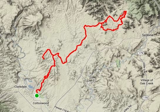
The cycling highlight of the month was riding from Dead Horse Ranch SP to Sedona for a 60-mile enduro.

I think that my aversion to driving to trailheads has taken a whole new meaning on this trip. This is clearly illustrated by yesterday's twenty-mile ride to the Aerie Trailhead. Oh yes, a twenty-mile ride to the trail does imply a twenty-mile ride back from the trail. I have to say that it was worth it though. It was a great six hours on the bike, all on dirt and I got to finish with the great DH at Dead Horse.

Thumper Trail at Dead Horse Ranch SP

 It was also a great example of why I ride so consistently. I like have the base fitness where I can come up with a long ride like that on a whim and just go out and do it. No train up, no preparation, just a base level of conditioning that allows me to enjoy pretty much any trail. I don't want to "survive" the ride. I want to enjoy the ride.

It is also a way of being prepared for the worst. If you are going to ride alone in the backcountry, you need to be able to get yourself out of any trouble you may find yourself in. This means having the fitness to not just complete the ride you have planned but also the ride you don't have planned.

One mechanical, one crash and any ride can turn into an unplanned epic.

Route from Dead Horse Ranch to the Aerie/Chuckwagon Loop at Sedona.


Monday, March 3, 2014

Do what you are good at.

Over the last three years I lost track of how many times I was asked what I planned to do when I finished my college degrees. It seemed that almost everyone was surprised when I answered that I would go back to working as a photographer.
Desert Garden is one of my most popular images.

For me, there was never any doubt what I would do because I really do love it. Traveling around the country documenting the world I see is the perfect job for me.

My love of photography may surprise many who know me because I really hate talking about it. I am not a techie, I don't care what kind of camera, lenses, tripods, etc... that people use to produce images. I only care about the final product which for me is the print. How you got from the shoot to the print is almost completely irrelevant and uninteresting to me, all I care about is how that image looks in its end state.

So, on what is almost the 20-year anniversary of my first image sale, I thought I might open up a little about what I really hate talking about.

One of my first published credits - Rock & Ice Magazine
A good place to start this discussion is to explain why I dislike talking shop. For me, that is easy. I do not believe that there is a right or wrong way to create something artistic. Like I said before, what matters is the final product and for me that is a photographic print.

I use Canon cameras and lenses, Epson printers and Moab papers. They work for me and I am comfortable with them. That is all that matters to me. I don't need the latest and greatest, I need a tool that will do what I need it to do. If you ask me for advice on what camera to buy, I probably won't have a clue. I don't really keep up on what is going on with the technology and only do research when I need to replace something. I use a 10-yearold camera with 15-year old lenses and as long as I don't see something that is exponentially better at the type of shooting I do, I don't see any reason to get something new just to have something new.

Too often when you talk to photographers, pros and amateurs alike, they have a workflow that they follow that they think is the best and they are insistent that their way is the right way to do things. I have no such illusions of grandeur. I have a workflow that works for me and it is quite simple.
Oxbow Bend - One of my favorite places.
 
I travel light in the field. I carry my camera attached to a carbon fiber tripod that I throw over my shoulder. I have a small PJ bag that will have one spare lens, two split neutral density filters, a brush to clean the lens and a spare battery. That's it. I see a lot of photographers out there with backpacks stuffed with every piece of gear they own. While they are playing around looking important, I am moving from shot to shot. I don't care if I look professional. I care about how many set ups I can do while the light is good. And for me, the light is only good for an hour on each side of sunrise and sunset. If it is overcast, I may do some macro shooting if there is something interesting.

For landscapes, I shoot in RAW, do an initial edit and conversion using Canon Digital Professional, open the file in Photoshop at actual size, check for dust and sharpness, fit to screen, unsharp mask if needed, check levels, insert file info, save at highest setting, done. That's it. My entire workflow in one easy process. Anything that needs more than that is more trouble than its worth and gets deleted.
I miss the days of film when it was so easy to put your slides on a light table and just trash everything that wasn't up to standard. Now there is so much temptation to try and "fix" those so-so images in PS. I would rather just go out and reshoot.

I have been doing my own printing since Epson came out with the first archival quality inks. I started with a 2000P and then progressed up to a 4000 for larger prints. I use Moab Entrada Paper because it fits the look I want for my prints. Some people like Canon, some like HP, I like Epson. There is no right or wrong, only taste.

Selling prints is an interesting business. It is a part of being a photographer that I both love and hate equally.
I love when someone buys one of my prints for the simple reason that they have seen something that somehow touched them and they have decided that they want to make it a part of their life by hanging it in their home. I cannot think of a greater honor as an artist and I really get upset with artists who somehow feel insulted if people don't buy their work. Just because you create something doesn't mean everyone will like it as much as you do. I have thousands of images in my files. Some of my personal favorites never sell. Some that I don't really like do. People have different tastes.
Rickett's Glen Cascade - Another favorite.

What I hate about selling prints is that sometimes it seems that people want you to sell them on why they should buy a print from you. I don't sell myself. I truly believe that that you should only buy art that you actually like. I would never hang anything on my wall just for that little name down in the corner.

All of my images are also available for stock licensing. I have an exclusive contract with Getty Images. I give them my images and they do all the marketing, licensing, collecting, etc... for me. They get their cut, I get mine. These are the images that are used for advertising, books, magazines, calendars, posters, etc... Most of my images are used in travel guides and magazines but I do find some interesting uses including the recent use of one of my bison images in Glamour Magazine. Over the years, my images have been used by National Geographic, Scientific American, Fodors, National Parks Conservation Association, U.S. Dept. of State and many others.

And this is what I love about my small niche in the photographic world. I am not the best photographer in the world but I shoot what I want and I am good enough to actually make some money doing something I enjoy. And that is something that I think everyone should try to do. Find something you like to do and figure out a way to make that your career.
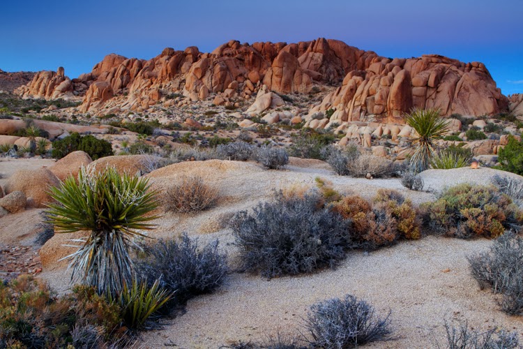
Twilight at Jumbo Rocks - One of my newest images.


Monday, February 24, 2014

Ride Report: Bootleg Canyon XC Trails

Just some of the XC trails at Bootleg.
Las Vegas has some of the best winter riding in the country. Whether you like road or dirt, Vegas has it all.

On the west side of town, you have Red Rocks and the sweet singletrack of the Cottonwood Trails and on the east side of town you have Boulder City and the world famous trails of Bootleg Canyon.

While bootleg is primarily known for its downhill trails, It also has a good selection of XC trails including a new connector that accesses the network from Henderson.

The trails are good enough to get the system rated as an IMBA Epic. It is also the location for the Interbike demo area.

Bootleg is not for beginners and it is not for the faint of heart. It rewards aggressive riding as you negotiate a never ending series of rocks, drops and sheer cliffs in this volcanic wonderland.

I've spent some time riding these trails and have found that the best tactic is to just charge every obstacle. If you timidly approach the obstacles, the rocks will take control. Speed and momentum are your friends.

Mother's Trail
Most of the XC trails are on the west side of the road with the Caldera and Mother's Trails being the most XC friendly. Par None and POW are probably the easiest of the DH trails and can be accessed from Mother's.

There are great facilities at the trailhead with water and even showers. They don't allow camping in the parking area anymore but the Boulder bay CG at lake Mead is only five miles away (and a good warm up if you decide to ride).

If you're in town without a bike, All-Mountain Cyclery is right at the bottom of the hill and can help you out.

Bootleg is definitely one of my favorite places to ride. There is always something to challenge you and the obstacle that you didn't clear today will be waiting for you to give it another go on your next ride.

Great trail system.

One of the best in the country.

Riding from the campground: Mother's Loop from Lake Mead


Saturday, February 15, 2014

MTB Ride Review: SARA Park (Lake Havasu)

You've got to give it up for the local riders/builders out here at Lake Havasu. They have done a good job putting together a really fun trail system.

Sara Park Trails
The route on the map is just about 25 miles and covers the Watershed Race Loop, Fun Fair (beginner trail), Beer Bottle, Blue Trail and some exploring on the north side of the park. There is still another 10-20 miles of trail out here that is not shown.

All of the trails are really fun with your typical wide open singletrack with swoopy turns in and out of drainages, over rocks etc... Really good stuff!

There are also at least two trails that go all the way to the lake giving you the opportunity to take a swim mid-way through your ride to cool off. This may be welcome as it does get hot out here. Today, it was 84 degrees at noon and I'm here in February.

Lake Havasu has pretty much anything you need. Plenty of lodging, restaurants and other activities to keep you entertained.

There are a couple of bike shops, River Cyclery & Sport (www.rivercyclery.com) and AZBuilt. River is more MTB oriented and Tony Beck (Owner) can give you some tips on the trails.

One great thing about this area is the bike trail that goes from town all the way to the trailhead so you don't have to deal with the limited parking on the weekends. You can also expect lots of hikers on the Red, Yellow & Blue trails on the weekends but if you head for the outer loops you'll pretty much have the trails to yourself.

Overall, I really liked this area. There is probably enough here to keep you entertained for at least a week. Combined with some interesting road riding this is almost a winter vacation destination.

Ride stats: Sara Park Loops

Sunset at Lake Havasu.


Friday, February 14, 2014

Ride Review: Joshua Tree National Park

I've been going to Joshua Tree for as long as I can remember.

Most of those trips were to go rock climbing but I have brought my mountain bike a couple of times to ride the Geology Tour Road route. This was the first time I've brought both bikes and really explored what the park has to offer cyclists.

Joshua Tree National Park showing my rides.
The best thing about riding in any of the National Parks is the scenery. Being able to ride in these spectacular places is always a treat. However, I think that for the most part the Park Service has done a horrible job with making cycling a viable option for seeing the park. There are exceptions to this. Zion, Grand Teton and Redwood have created bike trails and other facilities for cyclists.

Joshua Tree is a good example of what is bad about the parks. The roads are narrow with no paved shoulder even though the ground has been graded on both sides of the pavement. Combined with the twisty road, limited visibility and the fact that for some reason about 90% of people seem to completely lose their minds as soon as they enter any of the parks, this makes for a pretty dangerous ride. I honestly felt safer when I was out on Hwy 62 with a 65mph speed limit than I did in the park where it was 35.

The climb to Key's View.
This park is huge but only a small part on the west side is actually accessible to bikes. On the road I did a loop that did the park loop connected by Hwy 62 with a side trip to Key's View which overlooks the Coachella Valley. I also did most of this as an out and back so I could climb the West Entrance hill.

Both of the hills to get into the park were pretty good. The East Entrance hill was definitely tougher climbing 2400' over 12 miles. The other notable climb goes to Keys View through some of the largest Joshua Trees in the park.
On the MTB side, you are limited to the 4x4 roads that are scattered throughout the park. There isn't anything technically challenging but that isn't to say the riding is easy. The climb back up Geology Tour Road is steep and sandy in places. But like the other riding in the park, the views are awesome.

A good ride would be to start at Hidden Valley CG and ride out Bighorn Pass, do the Geology Tour route and return for about 25-30 miles.

My recommended routes:

MTB - Geology Tour w/Queen Valley Tour

Road - Jumbo Rocks to JTree w/Key's View

Twilight at Joshua Tree National Park.


Thursday, February 6, 2014

Ride Review: Moreno Valley

I spent the last week in the former foreclosure capital of Southern California. I didn't find any good deals on housing but the riding was pretty great.

I always go to new areas with the idea that I'll ride whatever is better between the road and the dirt. This week I found two pretty good road rides but spent the majority of my time exploring the trails of the Lake Perris State Recreation Area.

The better of the two road rides was the Oak Glen Loop, a 57-mile ride with 5300' of climbing with the cat 2 Oak Glen (east) climb. I've done this climb from the other side twice during the Breathless Agony Century so I wanted to give it a go from the other side. I managed to get into the Top-10 for the 15-mile climb starting at Live Oak so that went pretty well.

The other road ride I did was a loop that I spotted some local riders doing. Not bad but it seemed to be your typical shop ride loop that tended to avoid any good hills.

MRAP Downhill.
The real surprise for me was the mountain biking. I've been to Lake Perris on numerous occasions but have never ridden here. I always looked at the trail maps and saw that it was just a bunch of sandy horse trails. I had actually planned on making a couple of trips over to Sycamore Canyon while I was in the area but ended up riding at Lake Perris instead. I even managed to put together an 83.3-mile ride for the February Gran Fondo Challenge on STRAVA (Dirty Fondo).

The riding did have some sand as I expected but I also found a bunch of singletrack trails that were similar to those found at Sycamore Canyon and Southridge. The climbs are mostly moderate with the exception of the climb up to Terri Peak. There were two sections on this that weighed in with a grade of over 30 percent. Yes, it is that steep. I managed to get the KOM riding up the MRAP DH to the top of the peak. This was probably one of the steepest grades I've climbed but the surface was solid so it is ridable (shut-up legs).
The view from Terri Peak.


The trails are mostly decomposed granite over hard pack with some rock obstacles thrown in for fun. The soil type means that this place would be a good choice after a rain. It rained twice while I was here and it pretty much just made the conditions better as it packed down the sand.

There are plenty of other things to do at Lake Perris so this would be a great place for a family weekend. There is fishing, boating, hunting, hiking, etc...

The campground is huge with 100+ RV sites and 100+ tent sites. Everything is well maintained and the staff is pretty friendly.

Sunset at Lake Perris.


Thursday, January 30, 2014

MTB Trail Review: Hahn Buena Vista/Clara Burgess

Getting ready to drop in.
This is one of my favorite trails anywhere, not just Southern California.

This 17.5 mile loop takes you high into the desert mountains just south of Palm Springs starting with a stiff 4-mile climb up Dunn Road.

All that climbing will be rewarded though when you get to the top of Hahn Trail. This is one of the best trails in SoCal with 2.7 miles of twisty, rocky singletrack dropping over 1100' through some of the best desert scenery you'll find anywhere.

After a quick connector back to Dunn Road, you join up with Wild Horse which connects with the Clara Burgess Trail and another stiff climb to the top of Murray Hill and about the best view of the Palm Springs area.
Hahn Trail is super sweet.

From the top of Murray Hill you're in for some real fun. If you creep up to the edge, you'll see an improbable looking trail that seems to drop straight off the side of a cliff. Yep, that's where you're going.

I should mention that if you are not comfortable with heights, exposure, tight switchbacks and the possibility of death if you should go over the edge, go back down the way you came because the next 1.3 miles drop 1100+ feet at an average grade of 17%. Yeah, it's steep, loose and technical and if you're up for it, it's a blast.

When you get to the bottom, there is a trail sign. From here just keep going right until you can see the neighborhood where you started the ride. Take any of the trails back to the road (beware: some may get real steep). 

Directions: In Cathedral City - Park right at the theaters then follow Cathedral Canyon road south, keep making right turns following the fence until you see the entrance to Dunn Road. Enter and get ready to work. The first mile is pretty tough.

Map & Stats: Dunn Road/ Hahn Buena Vista


Murray Hill. Remember to look at where you want to go, not where you don't want to go.


Monday, January 27, 2014

10 Days in the Desert


Morning in the desert.
I've spent quite a bit of time in Anza-Borrego over the years camping, bouldering and mountain biking. It's interesting that in all that time and with the proximity to where I live, I've never really come out here specifically to shoot. I've collected a few shots along the way but weekend trips were usually for some other purpose.

I spent a couple of days shooting the badlands then moved up towards Borrego Palm Canyon where I spent the rest of my time. I was able to get what I consider adequate shots but nothing spectacular. Unfortunately, I've been blessed with clear skies, which for a photographer means boring skies. So I've spent most of my time looking for interesting foreground elements to put in front of the mountains to the west.

I was hoping for a few wildflowers but the drought that is keeping California dry has definitely dried out the desert areas as much if not more than everywhere else in the state.

Over the last few years my visits have been restricted to the Rodriguez/Oriflamme Canyon area during the Julian Death March so it has been nice to do a little exploring while I'm out here.


Ten days of riding at Borrego Valley.
For mountain biking, I started out with a cruise around the Grapevine Canyon Loop followed by a cruise through the desert badlands of Ocotillo Wells and then an out and back ride up Coyote Canyon about half way. All three rides were your typical desert riding with lots of rocks and sand. Call me crazy but I really don't mind it that much and just love the isolation of the desert.

Ocotillo Riding
I also had some plans for the road bike. I've been wanting to ride Montezuma Grade (cat 1) for some time now so staying right at the base gave me a chance to give it a go more than once.

The rest of the riding around the valley is mostly flat or false flats on pavement that ranges from rough to really horrible and by horrible I mean that suspension might be required depending on which road you're on.

One thing I learned pretty quick is that you have two choices when it comes to road riding from Borrego Springs. You can ride around the valley in which case you're going to ride some rough roads that will wear you down, or you can ride up Montezuma Grade to better pavement.

Since riding up Montezuma every day would be pretty rough, I did a number of rides around the valley. The east side of Yaqui Pass (cat 4) is another good climb I found in my exploring and actually had good pavement. The rest of the time I did out and backs to the 78 and down S22 towards Salton Sea.

About half way up Montezuma Grade.
The best two rides I did were the loops up Montezuma Grade. These were both excellent rides that are as good as anything I've ridden in San Diego.

On the first, I rode S22 up to San Felipe Road and turned left and followed San Felipe all the way to the 78 where I made another left then came back into Borrego Valley via the west side of Yaqui Pass. This was right at 50 miles and was a good 3-hour ride if you keep your pace up.

The second loop turned right at San Felipe Road and went through Santa Isabelle and Julian for a 75-mile loop with 6000+ feet of climbing.

Overall, I would rate Borrego Springs as a pretty good destination for riding. Montezuma Grade is pretty much the highlight for the road. The scenery is great wherever you ride though and the weather can't be beat.

Camping is also easy. You can stay at the State Park CG or camp for free on the BLM land east of town or at Ocotillo Wells State Vehicular Recreation Area. There is gas and food available in Borrego Springs along with a couple of small motels.

There is also a new bike shop at the mall. He mainly deals in rentals for the tourists but has some emergency parts if you find yourself needing a tire or tubes.

Sunrise in the desert.