Showing posts with label mountain biking. Show all posts

Friday, June 17, 2016

Trans Bernadino's Bikepacking

I like to think that every great adventure will somehow involve either a train or a ferry at some point along the way. For this adventure, I elected to use a train to get to and from the start/end of my ride.

I've been thinking about a dirt loop around the San Bernadino Mountains for a few years. I've done a good bit of riding around the Big Bear Lake area but haven't done much exploring outside of the valley so much of my planned route will be new terrain.
The planned route. I call it The Trans Bernadino's.
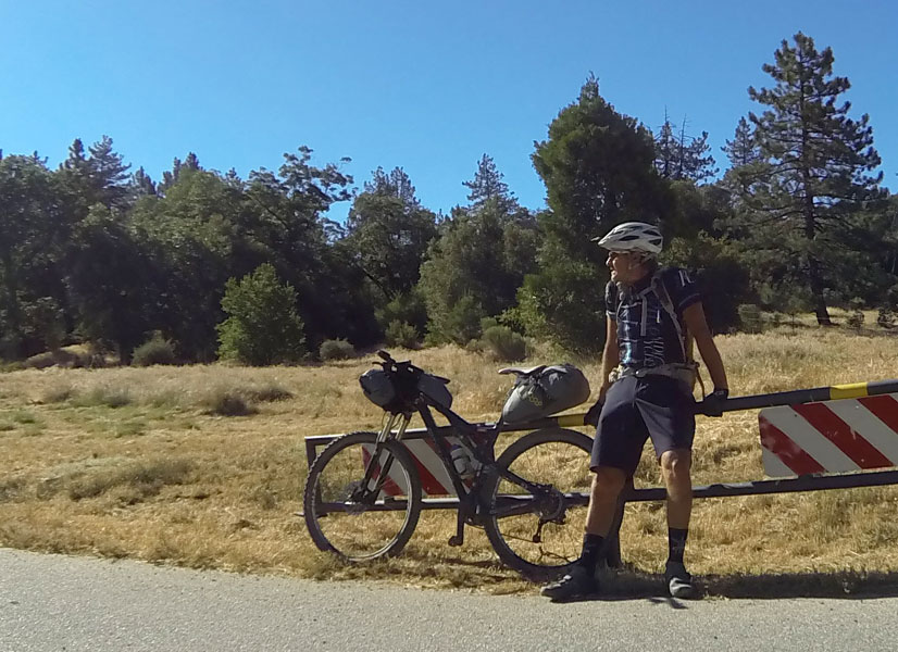
I planned to load up my mountain bike with a light load of sleeping bag, bivy sack, sleeping pad and enough gels and drink mix to get me through a planned 20 hours of riding to get around the 152-mile course. The plan was to finish in three days with a fourth if things didn't exactly go as planned. I've been on a couple of tours before so I know that nothing ever goes as planned.

After a easy 1.5 hour train ride from Irvine to San Bernadino, I set out on Old Route 66 up the Cajon Pass to Cleghorn Road and the start of the dirt.
Not the first time I've gotten my kicks on Route 66.

Cleghorn Road turned out to be much more pleasant than expected. I've ridden quite a few OHV roads and most are just horrible. I was actually expecting steep, loose conditions and a bunch of hike-a-bike but found a well-graded road that was actually a fun climb. Making it into the top-10 on the STRAVA segment on a fully loaded bike is always a nice ego boost also. The views of the high desert and the back side of Mt. Baldy are fantastic once you gain the ridge.

Great views on Cleghorn Ridge.
I ended the first day at Lake Silverwood State Park after riding 38 miles with 4500' of climbing. I felt good the whole way but am looking forward to a couple of tough days to finish this off.

The top of Miller Canyon.
Day two started off with a tough climb up Miller Canyon that finally made me push the bike through a couple of sections. Since I'm on unfamiliar turf, I will be trying to conserve energy as much as possible. Unfortunately, I will make a choice at the top that dooms me to some really tough riding. I had seen some OHV "trails" on the map that looked like singletrack and had decided these might be a fun way around Lake Arrowhead. These turned out to be motorcycle trails and the first one was actually really fun with banked turns, whoops and some cool features. The second, not so much. It just deteriorated into one super steep, loose climb after another until I was pretty worked.

Exploring the moto trails north of Lake Arrowhead.
I ended up bailing out after a couple of miles for the nearest road to town (I was also getting a little hungry) and this is where my plan went out the door. About a mile after I hit the pavement, one of the bolts holding my seat in place snapped leaving me with a seat flopping all over. I was able to McGuyver it well enough to ride the short distance to the bus stop where I caught the bus up to Bear Valley Bikes where they dug around and found a bolt that fit.

I missed out on around 15 miles of my planned route due to the unplanned bus ride but I was in position for day three which would take me up and over Wildhorse Meadow road and then all the way down the Santa Ana River Trail.

The climb up Wildhorse Meadows Road.
Day three started with a big breakfast and then a nice climb out of Big Bear Valley. After 2 hours, I was looking down at the Santa Ana River 2000' below.

The Santa Ana River Trail (SART) is a Southern California Classic. Miles of singletrack carved into the steep side of the canyon make for an awesome ride. Great views the entire way. Things were going great until Middle Control Road. Just after crossing the road there is a section that still has a bunch of downed trees and wash outs. This isn't too bad normally but lifting a fully loaded bike over trees gets a little old after 20 or 30 times. It also put me way behind schedule. I made it to Angeles Oaks just a few minutes before the restaurant closed and was able to get some food and water.

I also decided to make another route change due to the time and not wanting to risk running into worse trail conditions on the lower part of the trail. After a quick run down the Loch Leven trail, I was back on the road for the long run back to the San Bernadino Train Station. Three days, 135 miles, 13,000+ feet of climbing. Not bad for a quick trip to the local mountains.

The start of 35 miles of downhill.


Sunday, March 23, 2014

March has been one awesome month!!!

I would have a hard time remembering the last time I packed this much activity into one month (and it's not over yet).

Snow Canyon, Utah
The month started at Valley of Fire State park in Nevada and took me north to the St. George/Hurricane, Utah area, across northern Arizona to Page and then due south to Sedona. Along the way I shot at Valley of Fire SP, Snow Canyon SP, Quail Creek SP, Zion NP, Sand Hollow SP, Glen Canyon NRA and Dead Horse Ranch SP.

I thought about heading north from Page but wind and cold convinced me that south was the way to go. Since I had never really intended on being that far north this early in the year, this kind of puts me back on course.

I'm hoping over the next few weeks to catch any wildflower blooms that might be out there with the dry winter that we've had this year. I'm seeing a few patches here and there around Sedona so I'm hoping to catch something at a little lower elevation.

I've been putting some serious miles in on the mountain bike this month. This is primarily due to me being close to some of my all-time favorite trails. I've even found a few new gems along the way.

Riding in Valley of Fire
Some of the trails are well known like J.E.M., Gooseberry Mesa and the Sedona Trails but I also rode the St. George and Dead Horse Ranch Trails and found them to be as good as any of the rides at the more well known areas. St. George has done a great job at creating a huge network of trails that can be linked into some big rides.

The Dead Horse Ranch Trails were just a blast. I rode two days at Sedona where it was so crowded it was just annoying. I spent the rest of my time at Dead Horse and had much more fun.

Sunset at Zion Canyon

Monthly highlight:

The photo highlight for the month was Zion National Park.

Zion is in my opinion the most beautiful National Park we have. The dramatic red sandstone walls drop down to a idyllic narrow canyon where the Virgin River flows through cottonwood trees and desert foliage.

The park does get crowded even in the off-season but if you aren't afraid to walk a little you can ditch the crowds.

The other reason I love Zion is because it has excellent rock climbing, great mountain bike trails and one of the toughest road climbs in the country nearby.

The cycling highlight of the month was riding from Dead Horse Ranch SP to Sedona for a 60-mile enduro.

I think that my aversion to driving to trailheads has taken a whole new meaning on this trip. This is clearly illustrated by yesterday's twenty-mile ride to the Aerie Trailhead. Oh yes, a twenty-mile ride to the trail does imply a twenty-mile ride back from the trail. I have to say that it was worth it though. It was a great six hours on the bike, all on dirt and I got to finish with the great DH at Dead Horse.

Thumper Trail at Dead Horse Ranch SP

 It was also a great example of why I ride so consistently. I like have the base fitness where I can come up with a long ride like that on a whim and just go out and do it. No train up, no preparation, just a base level of conditioning that allows me to enjoy pretty much any trail. I don't want to "survive" the ride. I want to enjoy the ride.

It is also a way of being prepared for the worst. If you are going to ride alone in the backcountry, you need to be able to get yourself out of any trouble you may find yourself in. This means having the fitness to not just complete the ride you have planned but also the ride you don't have planned.

One mechanical, one crash and any ride can turn into an unplanned epic.
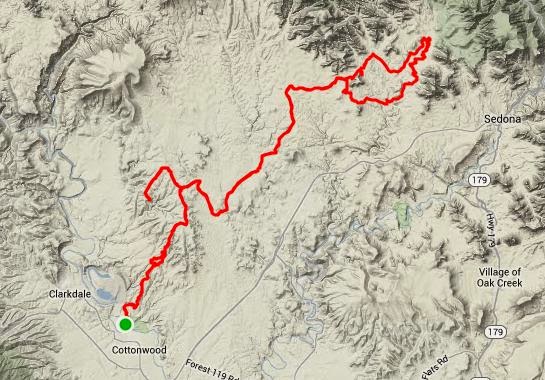
Route from Dead Horse Ranch to the Aerie/Chuckwagon Loop at Sedona.


Monday, February 24, 2014

Ride Report: Bootleg Canyon XC Trails

Just some of the XC trails at Bootleg.
Las Vegas has some of the best winter riding in the country. Whether you like road or dirt, Vegas has it all.

On the west side of town, you have Red Rocks and the sweet singletrack of the Cottonwood Trails and on the east side of town you have Boulder City and the world famous trails of Bootleg Canyon.

While bootleg is primarily known for its downhill trails, It also has a good selection of XC trails including a new connector that accesses the network from Henderson.

The trails are good enough to get the system rated as an IMBA Epic. It is also the location for the Interbike demo area.

Bootleg is not for beginners and it is not for the faint of heart. It rewards aggressive riding as you negotiate a never ending series of rocks, drops and sheer cliffs in this volcanic wonderland.

I've spent some time riding these trails and have found that the best tactic is to just charge every obstacle. If you timidly approach the obstacles, the rocks will take control. Speed and momentum are your friends.

Mother's Trail
Most of the XC trails are on the west side of the road with the Caldera and Mother's Trails being the most XC friendly. Par None and POW are probably the easiest of the DH trails and can be accessed from Mother's.

There are great facilities at the trailhead with water and even showers. They don't allow camping in the parking area anymore but the Boulder bay CG at lake Mead is only five miles away (and a good warm up if you decide to ride).

If you're in town without a bike, All-Mountain Cyclery is right at the bottom of the hill and can help you out.

Bootleg is definitely one of my favorite places to ride. There is always something to challenge you and the obstacle that you didn't clear today will be waiting for you to give it another go on your next ride.

Great trail system.

One of the best in the country.

Riding from the campground: Mother's Loop from Lake Mead


Saturday, February 15, 2014

MTB Ride Review: SARA Park (Lake Havasu)

You've got to give it up for the local riders/builders out here at Lake Havasu. They have done a good job putting together a really fun trail system.

Sara Park Trails
The route on the map is just about 25 miles and covers the Watershed Race Loop, Fun Fair (beginner trail), Beer Bottle, Blue Trail and some exploring on the north side of the park. There is still another 10-20 miles of trail out here that is not shown.

All of the trails are really fun with your typical wide open singletrack with swoopy turns in and out of drainages, over rocks etc... Really good stuff!

There are also at least two trails that go all the way to the lake giving you the opportunity to take a swim mid-way through your ride to cool off. This may be welcome as it does get hot out here. Today, it was 84 degrees at noon and I'm here in February.

Lake Havasu has pretty much anything you need. Plenty of lodging, restaurants and other activities to keep you entertained.

There are a couple of bike shops, River Cyclery & Sport (www.rivercyclery.com) and AZBuilt. River is more MTB oriented and Tony Beck (Owner) can give you some tips on the trails.

One great thing about this area is the bike trail that goes from town all the way to the trailhead so you don't have to deal with the limited parking on the weekends. You can also expect lots of hikers on the Red, Yellow & Blue trails on the weekends but if you head for the outer loops you'll pretty much have the trails to yourself.

Overall, I really liked this area. There is probably enough here to keep you entertained for at least a week. Combined with some interesting road riding this is almost a winter vacation destination.

Ride stats: Sara Park Loops

Sunset at Lake Havasu.


Friday, February 14, 2014

Ride Review: Joshua Tree National Park

I've been going to Joshua Tree for as long as I can remember.

Most of those trips were to go rock climbing but I have brought my mountain bike a couple of times to ride the Geology Tour Road route. This was the first time I've brought both bikes and really explored what the park has to offer cyclists.

Joshua Tree National Park showing my rides.
The best thing about riding in any of the National Parks is the scenery. Being able to ride in these spectacular places is always a treat. However, I think that for the most part the Park Service has done a horrible job with making cycling a viable option for seeing the park. There are exceptions to this. Zion, Grand Teton and Redwood have created bike trails and other facilities for cyclists.

Joshua Tree is a good example of what is bad about the parks. The roads are narrow with no paved shoulder even though the ground has been graded on both sides of the pavement. Combined with the twisty road, limited visibility and the fact that for some reason about 90% of people seem to completely lose their minds as soon as they enter any of the parks, this makes for a pretty dangerous ride. I honestly felt safer when I was out on Hwy 62 with a 65mph speed limit than I did in the park where it was 35.

The climb to Key's View.
This park is huge but only a small part on the west side is actually accessible to bikes. On the road I did a loop that did the park loop connected by Hwy 62 with a side trip to Key's View which overlooks the Coachella Valley. I also did most of this as an out and back so I could climb the West Entrance hill.

Both of the hills to get into the park were pretty good. The East Entrance hill was definitely tougher climbing 2400' over 12 miles. The other notable climb goes to Keys View through some of the largest Joshua Trees in the park.

On the MTB side, you are limited to the 4x4 roads that are scattered throughout the park. There isn't anything technically challenging but that isn't to say the riding is easy. The climb back up Geology Tour Road is steep and sandy in places. But like the other riding in the park, the views are awesome.

A good ride would be to start at Hidden Valley CG and ride out Bighorn Pass, do the Geology Tour route and return for about 25-30 miles.

My recommended routes:

MTB - Geology Tour w/Queen Valley Tour

Road - Jumbo Rocks to JTree w/Key's View

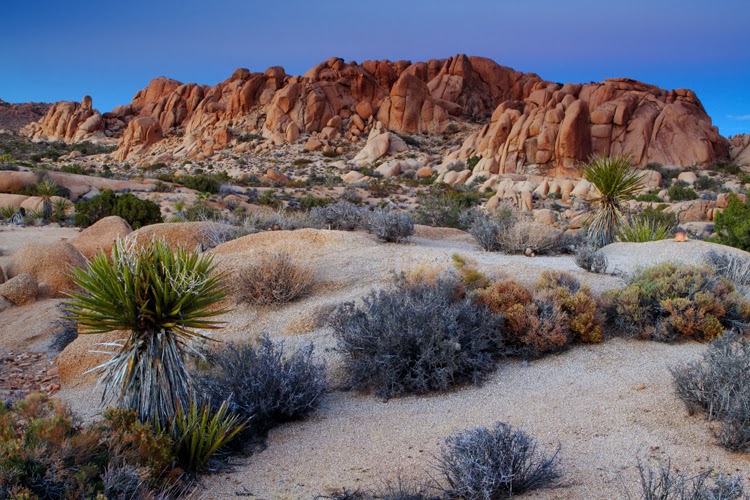
Twilight at Joshua Tree National Park.


Thursday, February 6, 2014

Ride Review: Moreno Valley

I spent the last week in the former foreclosure capital of Southern California. I didn't find any good deals on housing but the riding was pretty great.

I always go to new areas with the idea that I'll ride whatever is better between the road and the dirt. This week I found two pretty good road rides but spent the majority of my time exploring the trails of the Lake Perris State Recreation Area.

The better of the two road rides was the Oak Glen Loop, a 57-mile ride with 5300' of climbing with the cat 2 Oak Glen (east) climb. I've done this climb from the other side twice during the Breathless Agony Century so I wanted to give it a go from the other side. I managed to get into the Top-10 for the 15-mile climb starting at Live Oak so that went pretty well.

The other road ride I did was a loop that I spotted some local riders doing. Not bad but it seemed to be your typical shop ride loop that tended to avoid any good hills.

MRAP Downhill.
The real surprise for me was the mountain biking. I've been to Lake Perris on numerous occasions but have never ridden here. I always looked at the trail maps and saw that it was just a bunch of sandy horse trails. I had actually planned on making a couple of trips over to Sycamore Canyon while I was in the area but ended up riding at Lake Perris instead. I even managed to put together an 83.3-mile ride for the February Gran Fondo Challenge on STRAVA (Dirty Fondo).

The riding did have some sand as I expected but I also found a bunch of singletrack trails that were similar to those found at Sycamore Canyon and Southridge. The climbs are mostly moderate with the exception of the climb up to Terri Peak. There were two sections on this that weighed in with a grade of over 30 percent. Yes, it is that steep. I managed to get the KOM riding up the MRAP DH to the top of the peak. This was probably one of the steepest grades I've climbed but the surface was solid so it is ridable (shut-up legs).
The view from Terri Peak.


The trails are mostly decomposed granite over hard pack with some rock obstacles thrown in for fun. The soil type means that this place would be a good choice after a rain. It rained twice while I was here and it pretty much just made the conditions better as it packed down the sand.

There are plenty of other things to do at Lake Perris so this would be a great place for a family weekend. There is fishing, boating, hunting, hiking, etc...

The campground is huge with 100+ RV sites and 100+ tent sites. Everything is well maintained and the staff is pretty friendly.

Sunset at Lake Perris.


Thursday, January 30, 2014

MTB Trail Review: Hahn Buena Vista/Clara Burgess

Getting ready to drop in.
This is one of my favorite trails anywhere, not just Southern California.

This 17.5 mile loop takes you high into the desert mountains just south of Palm Springs starting with a stiff 4-mile climb up Dunn Road.

All that climbing will be rewarded though when you get to the top of Hahn Trail. This is one of the best trails in SoCal with 2.7 miles of twisty, rocky singletrack dropping over 1100' through some of the best desert scenery you'll find anywhere.

After a quick connector back to Dunn Road, you join up with Wild Horse which connects with the Clara Burgess Trail and another stiff climb to the top of Murray Hill and about the best view of the Palm Springs area.
Hahn Trail is super sweet.

From the top of Murray Hill you're in for some real fun. If you creep up to the edge, you'll see an improbable looking trail that seems to drop straight off the side of a cliff. Yep, that's where you're going.

I should mention that if you are not comfortable with heights, exposure, tight switchbacks and the possibility of death if you should go over the edge, go back down the way you came because the next 1.3 miles drop 1100+ feet at an average grade of 17%. Yeah, it's steep, loose and technical and if you're up for it, it's a blast.

When you get to the bottom, there is a trail sign. From here just keep going right until you can see the neighborhood where you started the ride. Take any of the trails back to the road (beware: some may get real steep). 

Directions: In Cathedral City - Park right at the theaters then follow Cathedral Canyon road south, keep making right turns following the fence until you see the entrance to Dunn Road. Enter and get ready to work. The first mile is pretty tough.

Map & Stats: Dunn Road/ Hahn Buena Vista


Murray Hill. Remember to look at where you want to go, not where you don't want to go.


Monday, January 27, 2014

10 Days in the Desert


Morning in the desert.
I've spent quite a bit of time in Anza-Borrego over the years camping, bouldering and mountain biking. It's interesting that in all that time and with the proximity to where I live, I've never really come out here specifically to shoot. I've collected a few shots along the way but weekend trips were usually for some other purpose.

I spent a couple of days shooting the badlands then moved up towards Borrego Palm Canyon where I spent the rest of my time. I was able to get what I consider adequate shots but nothing spectacular. Unfortunately, I've been blessed with clear skies, which for a photographer means boring skies. So I've spent most of my time looking for interesting foreground elements to put in front of the mountains to the west.

I was hoping for a few wildflowers but the drought that is keeping California dry has definitely dried out the desert areas as much if not more than everywhere else in the state.

Over the last few years my visits have been restricted to the Rodriguez/Oriflamme Canyon area during the Julian Death March so it has been nice to do a little exploring while I'm out here.


Ten days of riding at Borrego Valley.
For mountain biking, I started out with a cruise around the Grapevine Canyon Loop followed by a cruise through the desert badlands of Ocotillo Wells and then an out and back ride up Coyote Canyon about half way. All three rides were your typical desert riding with lots of rocks and sand. Call me crazy but I really don't mind it that much and just love the isolation of the desert.

Ocotillo Riding
I also had some plans for the road bike. I've been wanting to ride Montezuma Grade (cat 1) for some time now so staying right at the base gave me a chance to give it a go more than once.

The rest of the riding around the valley is mostly flat or false flats on pavement that ranges from rough to really horrible and by horrible I mean that suspension might be required depending on which road you're on.

One thing I learned pretty quick is that you have two choices when it comes to road riding from Borrego Springs. You can ride around the valley in which case you're going to ride some rough roads that will wear you down, or you can ride up Montezuma Grade to better pavement.

Since riding up Montezuma every day would be pretty rough, I did a number of rides around the valley. The east side of Yaqui Pass (cat 4) is another good climb I found in my exploring and actually had good pavement. The rest of the time I did out and backs to the 78 and down S22 towards Salton Sea.

About half way up Montezuma Grade.
The best two rides I did were the loops up Montezuma Grade. These were both excellent rides that are as good as anything I've ridden in San Diego.

On the first, I rode S22 up to San Felipe Road and turned left and followed San Felipe all the way to the 78 where I made another left then came back into Borrego Valley via the west side of Yaqui Pass. This was right at 50 miles and was a good 3-hour ride if you keep your pace up.

The second loop turned right at San Felipe Road and went through Santa Isabelle and Julian for a 75-mile loop with 6000+ feet of climbing.

Overall, I would rate Borrego Springs as a pretty good destination for riding. Montezuma Grade is pretty much the highlight for the road. The scenery is great wherever you ride though and the weather can't be beat.

Camping is also easy. You can stay at the State Park CG or camp for free on the BLM land east of town or at Ocotillo Wells State Vehicular Recreation Area. There is gas and food available in Borrego Springs along with a couple of small motels.

There is also a new bike shop at the mall. He mainly deals in rentals for the tourists but has some emergency parts if you find yourself needing a tire or tubes.

Sunrise in the desert.


Tuesday, January 14, 2014

Finding your pure joy...

I was on a slight downhill today on a winding road that twisted its way through a corridor of tall eucalyptus trees when I eased up, let go of my handlebars, sat up and spread my arms like wings as I descended through the forest like a bird.

It happened without me thinking about it, just a moment in which I was transported back to my younger years when riding a bike granted me freedom and at the same time one of my first forms of recreation independent of parents, independent of others, something that could be pursued alone or with friends depending on your mood.

I remember learning to ride. I remember those first pedal strokes in the alley behind our apartment in Tustin, the first crash into the dumpster because I didn't bother learning how to use the brakes. I remember my first trip to the hospital. I remember the first bike I broke sliding into a wall at Fullerton Stadium.

I can remember riding 10-speeds fifty-miles round trip to the beach from Fullerton when I was in high school, riding BMX bikes on the dirt and in the local skate parks during the early '80s.

I took a break from riding in the mid-to-late '80s when I was in the Army and when I surfed a lot. But I got back on the bike around 1990 and really haven't stopped since.

Riding brings me joy. It challenges me and allows me to challenge myself. Unlike surfing or skiing, the riding is always good. I don't have to wait for good surf or snow. I can swing my leg over a bike and hit the road or trails and lose myself in the exertion for as long as I desire. I am not bound by the whims of nature. I am only constrained by the power of my legs, the capacity of my lungs, the pumping of my heart and the strength of my mind to overcome any pain I dish out to myself.

And on occasion, I have a moment like today where I am transported back to where I am lost in the pure joy of riding that I had when I first learned to pedal as a child.


Wednesday, January 8, 2014

Week one is in the books...

The first week of the 2014 Photo/Ride Adventure Tour is in the books and has carried me from South Orange County to North San Diego County. Not a lot of mileage but since I'm not on a strict timetable as in times past, this should give me the opportunity to get better coverage of the areas I do visit.

A good example would be the time I've spent at South Carlsbad State Park. In the past I would have stayed for a sunset and sunrise and taken whatever I happened to capture. In this case, the first two sunsets were rather bland and didn't really get me anything good. The third however got some interesting cloud formations that yielded this image.


Copyright Eric Foltz
With limited features other than a lot of wide open stretches of sand, finding some rocks to put in the foreground made all the difference. It's not the best beach image I have but I'm pretty happy with being able to get something good from this location.

I was able to put up pretty good mileage on the bikes (plural). I did some mountain biking while I was up in San Clemente and have been mixing it up with road biking when the trails weren't convenient.

I've managed to ride the Southern California coast from Seal Beach to La Jolla with a couple of inland loops to keep it interesting.

Riding in San Diego County really makes you appreciate how good the roads in South OC really are. PCH through SD is one cracked, potholed, lumpy mess in a lot of places. The views are spectacular but taking your eyes off the pavement in front of you is risking death.

The STRAVA Heatmap so far:
I'll probably have a hard time turning anything red this year, but I predict there will be blue lines all over the place by year's end.

I was hoping to hit around 5000 new segments by the end of the year, but I'm thinking that number might be a little conservative since I've already added around 300 in just the first week. It's is really amazing to see what happens when you ride something in the opposite direction from what you do normally. Yesterday and today, I rode north along the coast where I had only ridden south previously and added 200+ segments. All those STRAVA users have been busy.


The real challenge will be adding to this map which shows everywhere I've ridden in the U.S.:

Mountain bike rides are green, road are red and my tour route is in gold. I'm looking forward to adding a lot of new color to this map.

Sunday, May 17, 2009

Big Bear Opening Weekend

For most Southern Californians, opening day at Snow Summit comes sometime during November or December as soon as there is enough snow to open the lifts for skiing and snowboarding.

For mountain bikers, opening day comes in May when the snow has melted and the trails are open for a summer of lift assisted downhill riding.

This weekend was the first time I've ridden the trails at Big Bear in at least ten years. I used to ride here a lot. Between the races and leading group rides for clubs, I spent quite a bit of time riding the trails at Big Bear.

I was living out of the area and country from 2001-2005 and missed the season and accident that led to the management of Snow Summit closing the trails within the ski area. Since then for some reason I just didn't make it up to the area to ride.

I was invited by some friends to join them for opening weekend and ended up having a blast. I explored trails I haven't ridden in years, rode the old cross-country courses from when I used to race and reaquainted myself with an area that has so much mountain bike history.

There is something special about riding in real mountains.


The smell of the pine trees, riding down steep, rooty, rocky trails all make it a special experience.


Sure the ski area is closed to riding, but here's the real secret of Big Bear, the best trails were never on the Ski Area, they are out in the National Forest waiting for a whole new generation of riders to make their own history.

And maybe we'll never get a bike park built like Mammoth, Northstar or Whistler, but that doesn't mean we can't have fun riding with our friends in a beautiful alpine environment.


Big Bear is and always will be a great place to ride. Get out there and have fun.