Thursday, January 23, 2014

Road Ride Review: Montezuma Grade/Yaqui Pass Loop

You just know that any ride that starts with a 3400' climb is going to be tough and this one doesn't disappoint.

Montezuma Grade/Yaqui Pass Loop
Montezuma Grade starts in the desert town of Borrego Springs and climbs foe 10.7 miles up to the small town of Ranchita. The entire climb is in the Anza-Borrego Desert State Park which is one of the largest state parks in the country showcasing the beautiful low desert of Southern California.

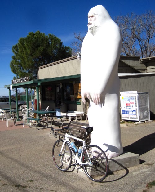
Store at Ranchita
The initial climb is tough. I watched the grade and it seemed to stay between 6-8% for the majority of the climb. I never saw it go above 9% or drop below 4% the whole way so it is pretty relentless. The climb is listed as the 60th hardest in California which has some pretty stiff climbs.

Once you get to the top, you are in for a lot of downhill riding with two small climbs at San Felipe Pass and Yaqui Pass (cat 4). The rest of the ride is pretty much downhill the whole way.

San Felipe road has a good shoulder for the whole way although the pavement is not the best I've seen. Once you turn on the 78, things get a little interesting as the road is pretty narrow as you drop through some tight turns for a few miles until you get to Yaqui Pass Road.

I would not recommend this section on a Friday or Saturday as you would have a lot of off-roader traffic heading to Ocotillo Wells. Motorhomes and trailers pulled by throttle jockeys are usually not a cyclists best friend on narrow roads.

After the short climb to Yaqui Pass, it's just a long downhill back to Borrego Springs where there are plenty of restaurants to hit up for some post-ride grub.

The route logs in at just over 50 miles with 4400' of climbing. I managed to get around in just over three hours.
 

Saturday, January 18, 2014

Road Ride Review - Sunrise Highway Loop

What an awesome ride. Good climb, good downhills, spectacular views throughout. This ride takes you from desert to mountains on good roads with not too much traffic.

Sunrise Highway Loop
I started at the Paso Picacho Campground in Cuyamaca Rancho State Park and did a counter-clockwise loop. I think the route would be just as fun in either direction.

The route ended up being 45.4 miles with just under 4000' of climbing so be prepared for some hills. The longest was the climb from Pine Valley up to Mount Laguna, a Category 1 climb that gains 2200' over 11 miles. The rest of the climbs are easy compared to that one.

The views along the way are fantastic and I would say this is as scenic as anything you'll find in Southern California. At one point as you descend the ridge coming down from Mount Laguna, you can look to your right and see far out into the Anza-Borrego Desert. You can also see the Pacific Crest Trail below you as it parallels the highway for a few miles.

Directions: Take the I-8 east out of San Diego to Pine Valley, start here or go west on Old Hwy 80 to the 79, take the 79 to Paso Picacho CG. 
High up on Sunrise Highway in the Laguna Mountains Recreation Area.


Tuesday, January 14, 2014

Finding your pure joy...

I was on a slight downhill today on a winding road that twisted its way through a corridor of tall eucalyptus trees when I eased up, let go of my handlebars, sat up and spread my arms like wings as I descended through the forest like a bird.

It happened without me thinking about it, just a moment in which I was transported back to my younger years when riding a bike granted me freedom and at the same time one of my first forms of recreation independent of parents, independent of others, something that could be pursued alone or with friends depending on your mood.

I remember learning to ride. I remember those first pedal strokes in the alley behind our apartment in Tustin, the first crash into the dumpster because I didn't bother learning how to use the brakes. I remember my first trip to the hospital. I remember the first bike I broke sliding into a wall at Fullerton Stadium.

I can remember riding 10-speeds fifty-miles round trip to the beach from Fullerton when I was in high school, riding BMX bikes on the dirt and in the local skate parks during the early '80s.

I took a break from riding in the mid-to-late '80s when I was in the Army and when I surfed a lot. But I got back on the bike around 1990 and really haven't stopped since.

Riding brings me joy. It challenges me and allows me to challenge myself. Unlike surfing or skiing, the riding is always good. I don't have to wait for good surf or snow. I can swing my leg over a bike and hit the road or trails and lose myself in the exertion for as long as I desire. I am not bound by the whims of nature. I am only constrained by the power of my legs, the capacity of my lungs, the pumping of my heart and the strength of my mind to overcome any pain I dish out to myself.

And on occasion, I have a moment like today where I am transported back to where I am lost in the pure joy of riding that I had when I first learned to pedal as a child.


Sunday, January 12, 2014

Road Ride (San Diego): Elfin Forest Loop

Elfin Forest/Del Dios Loop
There are a lot of good routes in San Diego but I think this might be my favorite. The route starts and ends on Pacific Coast Highway and the world famous views that it is known for but the real highlights are Elfin Forest Road and Del Dios Highway out near Lake Hodges.

The loop shown on the map is right around 40 miles but it would be pretty easy to add or subtract miles.

The route can also be ridden clockwise or counter-clockwise. It seemed that more riders were going counter-clockwise on the Sunday that I rode the route. The climbs might be slightly tougher in that direction.

Elfin Forest Road
With the exception of a few miles on Elfin Forest and La Costa, there was either a shoulder or a dedicated bike lane. The ride felt as safe as any other rural route I've ridden in Southern California.

 I was reminded of the riding in the Santa Monica's with the same Coastal Scrub Oak Chaparral that dominates the coastal areas of Southern California. Or at least it used to dominate before most of it was turned into planned suburbia.

This loop has many miles that is bordered by either the Elfin Forest or Lake Hodges Reserves which give a look back at what the area used to look like.

Lake Hodges from Del Dios Highway.

Wednesday, January 8, 2014

Week one is in the books...

The first week of the 2014 Photo/Ride Adventure Tour is in the books and has carried me from South Orange County to North San Diego County. Not a lot of mileage but since I'm not on a strict timetable as in times past, this should give me the opportunity to get better coverage of the areas I do visit.

A good example would be the time I've spent at South Carlsbad State Park. In the past I would have stayed for a sunset and sunrise and taken whatever I happened to capture. In this case, the first two sunsets were rather bland and didn't really get me anything good. The third however got some interesting cloud formations that yielded this image.


Copyright Eric Foltz
With limited features other than a lot of wide open stretches of sand, finding some rocks to put in the foreground made all the difference. It's not the best beach image I have but I'm pretty happy with being able to get something good from this location.

I was able to put up pretty good mileage on the bikes (plural). I did some mountain biking while I was up in San Clemente and have been mixing it up with road biking when the trails weren't convenient.

I've managed to ride the Southern California coast from Seal Beach to La Jolla with a couple of inland loops to keep it interesting.

Riding in San Diego County really makes you appreciate how good the roads in South OC really are. PCH through SD is one cracked, potholed, lumpy mess in a lot of places. The views are spectacular but taking your eyes off the pavement in front of you is risking death.

The STRAVA Heatmap so far:
I'll probably have a hard time turning anything red this year, but I predict there will be blue lines all over the place by year's end.

I was hoping to hit around 5000 new segments by the end of the year, but I'm thinking that number might be a little conservative since I've already added around 300 in just the first week. It's is really amazing to see what happens when you ride something in the opposite direction from what you do normally. Yesterday and today, I rode north along the coast where I had only ridden south previously and added 200+ segments. All those STRAVA users have been busy.


The real challenge will be adding to this map which shows everywhere I've ridden in the U.S.:

Mountain bike rides are green, road are red and my tour route is in gold. I'm looking forward to adding a lot of new color to this map.

Sunday, May 31, 2009

Tioga Pass

Another great day in the Eastern Sierras. The area between Lone Pine and Bridgeport is quite possibly one of the most beautiful areas in the U.S.

To the west of Highway 395 lies the Sierra Nevada Mountain Range. There are a number of passes crossing the Sierras including Tioga Pass which is the Eastern gateway to Yosemite National Park.
The road to Tioga Pass starts in the small town of Lee Vining which lies just above the world famous Mono Lake.

Cyclists from all over the world come to the Sierras to test themselves on some of the toughest hill climbs on earth.

The Tioga Pass climb is moderate by Sierra standards but is still a great ride. The ride goes for 11.8 miles and climbs 3129' to Tioga Pass at 9945' above sea level. Along the way are some absolutely beautiful scenes.

The pass itself lies at the eastern entrance to Yosemite.

Like I said, another great day in the Eastern Sierras.

Sunday, May 17, 2009

Big Bear Opening Weekend

For most Southern Californians, opening day at Snow Summit comes sometime during November or December as soon as there is enough snow to open the lifts for skiing and snowboarding.

For mountain bikers, opening day comes in May when the snow has melted and the trails are open for a summer of lift assisted downhill riding.

This weekend was the first time I've ridden the trails at Big Bear in at least ten years. I used to ride here a lot. Between the races and leading group rides for clubs, I spent quite a bit of time riding the trails at Big Bear.

I was living out of the area and country from 2001-2005 and missed the season and accident that led to the management of Snow Summit closing the trails within the ski area. Since then for some reason I just didn't make it up to the area to ride.

I was invited by some friends to join them for opening weekend and ended up having a blast. I explored trails I haven't ridden in years, rode the old cross-country courses from when I used to race and reaquainted myself with an area that has so much mountain bike history.

There is something special about riding in real mountains.


The smell of the pine trees, riding down steep, rooty, rocky trails all make it a special experience.


Sure the ski area is closed to riding, but here's the real secret of Big Bear, the best trails were never on the Ski Area, they are out in the National Forest waiting for a whole new generation of riders to make their own history.

And maybe we'll never get a bike park built like Mammoth, Northstar or Whistler, but that doesn't mean we can't have fun riding with our friends in a beautiful alpine environment.


Big Bear is and always will be a great place to ride. Get out there and have fun.